RT, citing Russian Ministry of Defence material and commentary, describes Russian military topographers as participants in the 2022 phase and names PNGK-1 among mobile navigation-geodetic complexes used for topogeodetic and navigation support; the evidence is Russian-state reporting rather than independent visual confirmation.
Role detailsPNGK-1 mobile navigation-geodetic complex
- PNGK-1
- ПНГК-1
- Подвижный навигационно-геодезический комплекс ПНГК-1
- Podvizhnyy navigatsionno-geodezicheskiy kompleks PNGK-1
- Mobile navigation-geodetic complex PNGK-1
- Mobile topogeodetic equipment PNGK-1
PNGK-1 is a Russian mobile navigation-geodetic complex for topogeodetic support rather than a direct combat weapon. Public product data and technical reporting describe a KamAZ-4350 based system that determines horizontal coordinates and elevations while moving or stopped, transfers coordinates to surveyed points, and supports troop movement routes, geodetic-network recovery, and operational navigation-geodetic support. Russian-state reporting also names PNGK-1 among systems used by Russian military topographers in the 2022 phase of the 2014 Russia-Ukraine War.
Role in Conflicts
Profile / Specs
Profile
- Origin
- Russia
- Type
- Mobile navigation-geodetic support complex
- Service note
- Russian navigation-geodetic support equipment accepted into Russian Armed Forces supply in 2004 and reported in district deliveries from 2012.
- Designer
- 106 Experimental Optical-Mechanical Plant
- Produced
- Accepted into Russian Armed Forces supply in 2004; Eastern Military District deliveries reported in 2012-2016
Specifications
- Primary role
- Rapid determination of horizontal coordinates and elevation points in motion and at halts
- Vehicle base
- KamAZ-4350 chassis with K4350D van body
- Real-time accuracy
- Reported coordinate and elevation error not more than 15 m while moving on a route
- Adjusted accuracy
- Reported coordinate and elevation error not more than 1 m when using navigation-geodetic satellite receiver data
- Navigation receivers
- Geodetic dual-frequency GPS/GLONASS Sura-K satellite receivers listed for operator and autonomous receiver workstations
- Workstations
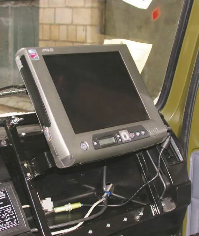
- Operator workstation, crew-chief workstation with industrial tablet computer, and autonomous satellite-receiver workstation
- Coordinate transfer
- Range-angle device listed for transferring coordinates from the complex to the point being determined
- Software and cabling
- Specialized software and a connection-cable kit are listed in the product composition
- Crew and setup
- Reported crew of three with measurement preparation time of not more than 30 minutes
- Reported field functions
- District reporting describes route-coordinate determination, geodetic-network survey and restoration, GLONASS/GPS-based geodetic control, and three-dimensional terrain-model construction
- Power
- ABP 1.5 230 VR generator set plus autonomous battery supplies listed for onboard equipment
Navigation-Geodetic Role
PNGK-1 is best read as a field geodetic support vehicle: it supplies location, elevation, route, and terrain-control data for military topographic work rather than carrying weapons. The public product listing defines the vehicle around workstations, satellite receivers, coordinate-transfer equipment, software, cables, and independent power; Russian district reporting adds route and geodetic-network tasks.
Determine horizontal coordinates and elevations of terrain points while the vehicle is moving or stopped.
KamAZ-4350 chassis with K4350D van body, operator and crew-chief workstations, and an autonomous satellite-receiver workstation.
Dual-frequency GPS/GLONASS Sura-K receivers, a specialized computing unit, industrial tablet computer, and specialized software are listed for the complex.
TASS reporting gives not more than 15 m error in real time on a route and not more than 1 m when satellite receiver data are used.
Delivery reports describe route-coordinate determination, geodetic-network survey and restoration, GLONASS/GPS geodetic-control work, and terrain-model construction.
Timeline
PNGK-1 mobile navigation-geodetic complex Key Events
Accepted into Russian supply
A Krasnaya Zvezda interview carried by VPK.name says PNGK-1 entered Russian Armed Forces supply in 2004 for geodetic and topogeodetic units.
Sources: Krasnaya Zvezda Topographic Service Interview
Technical article published
Geodesy and Cartography published a PNGK-1 article describing the complex and test results for near-real-time geodetic tasks.
Sources: Geodesy and Cartography PNGK-1 Article
Eastern Military District deliveries reported
A TASS report carried by VPK.name said four KamAZ-based PNGK-1 complexes had been delivered to Eastern Military District troops in 2012 and nine more were planned in 2013.
Sources: TASS PNGK-1 Eastern District Delivery
PNGK-1 product listing created
Bizorg service information records the PNGK-1 listing as created on 28 August 2013 and last modified on 15 November 2013.
Sources: PNGK-1 Product Listing
Khabarovsk geospatial center receives PNGK-1
TsAMTO reporting carried by VPK.name said PNGK-1 complexes entered the Eastern Military District geospatial information and navigation center in Khabarovsk.
Sources: TsAMTO PNGK-1 Khabarovsk Delivery
PNGK-1 development recognized
The Russian Society of Geodesy, Cartography and Land Management listed the 2019 F. N. Krasovsky Prize for the development, creation, and implementation of PNGK-1.
Sources: Rosgeokart Krasovsky Prize Winners
Reported use in Ukraine support work
RT, in an article on Russian military topographers during the 2022 phase of the war in Ukraine, named PNGK-1 among mobile navigation-geodetic complexes used for topogeodetic and navigation support.
Sources: RT Russian Military Topographers Article
Related Weapon Systems


